(Spanish and English versions)
Mapas cognitivos, memoria espacial y recursos alimenticios en monos aulladores negros en el Parque Nacional Palenque
Se ha descrito que los primates poseen habilidades cognitivas que les permiten almacenar información relativa a la ubicación, cantidad y calidad de numerosos sitios de alimentación dentro de sus ambitos hogareños. Se ha propuesto que esta información espacial esta codificada en mapas cognitivos que permiten a los primates navegar óptimamente dentro de su entorno. Un mapa basado en rutas permite al individuos navegar su habitat utilizando una red de rutas que conecta múltiples sitios de alimentación y reposo. Un mapa basado en coordenadas permite al individuo codificar y recuperar la ubicación de sitios de aimentacion a traves de coordenadas X y Y que podria resultar en un uso más flexible de las distancias y direcciones.
El estudio sobre los mapas cognitivos inicio en Enero del 2016 en el Parque Nacional Palenque en el sureste de Mexico y consiste en el seguimiento diario de cinco grupos de monos aulladores negros (Alouatta pigra) para registrar sus rutas de viaje y recursos alimentarios utilizados, así como las interacciones competitivas vocales o directas con grupos vecinos. Los árboles utilizados por los aulladores como fuentes de alimento (hojas, frutos, flores) se miden (dbh/altura), su ubicacion es registrada con un gps y son identificados a nivel de especie. La conectividad del dosel se calcula utilizando un luxometro digital y drones. Tambien se llevan a cabo censos fenológicos quincenales de unos 1000 árboles a lo largo de un trayecto de 10km de argo y ubicado en el area de selva ocupada por los cinco grupos.
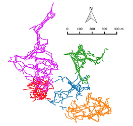
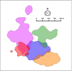
Las imágenes de la derecha muestran los ambitos hogareños de los 5 grupos y un ejemplo de los patrones de rutas de viaje mensuales para cada grupo al buscar árboles de alimentación. Los colores de las rutas identifican la ubicacion espacial de cada grupo como en la imagen izquierda.
El uso de tecnologias inovadoras para estudios de campo con primates como es el caso de drones nos esta ayudando a mapear la vegetación del dosel de la selva habitada por los aulladores por medio de fotografías de alta resolución con la meta de contar con una medida más precisa de la conectividad del dosel a través de la generación de ortomosaicos y sometiendo estos a análisis por algoritmos que nos pueden indicar la proporción de “canopy cover” por unidad de área en el ámbito de cada grupo. Generando los ortomosaicos a tiempos diferentes podremos contar con información sobre la variación en el ciclo anual en está métrica para cada grupo. Asimismo, los ortomosaicos pueden someterse a otros algoritmos que pueden medir la reflectancia de la vegetación y dar una indicación general, pero cuantitativa, sobre el porcentaje de áreas con mayor o menor actividad fotosintética y por ende con más hojas jóvenes que maduras. Uno de los elementos más importantes en la dieta anual de los aulladores son las hojas jóvenes. Esta informacion acoplada a aquella derivada de las observacion de la conducta espacial y uso de recursos alimenticios no ayudara a modelar con mayor precision el comportamiento espacial de los aulladores. Asi entenderemos como se adaptan a la variacion espacial y temporal en la disponibilidad de sus recursos y a las discontuidades en la connectividad del dosel de la selva.
Los conocimientos generados de este estudio podrán aplicarse más adelante al entendimiento de cómo las estrategias de adquisición de recursos manifestadas por el mono aullador negro, especie en peligro de extincion, en ambientes ecológicamente estables, son alteradas como resultado de la fragmentación del hábitat causada por la actividad humana. Esto podrá permitir la simulación de modelos de manejo espacial de paisajes fragmentados que armonicen con la actividad agropecuaria y sean facilitadores de la supervivencia de estas poblaciones, por ejemplo, al establecer conectores arbolados entre nodos de vegetación.
Cognitive maps, spatial memory and food resources in black howler monkeys (Alouatta pigra) in Palenque National park
Primates have been described to possess cognitive skills that enable them to store information relative to the location, quantity, and quality of numerous feeding sites within their home range. This spatial information has been proposed to be encoded in cognitive maps that allow primates to navigate optimally within their environment. A route-based map allows the forager to navigate using a route network that connects multiple feeding and resting sites. A coordinate-based map allows the forager to encode and recall the location of important sites as x and y coordinates providing a more flexible use of distances and directions.
The study of the cognitive maps of black howler monkeys was launched in January 2016 and it involves daily monitoring of five black howler monkey groups (Alouatta pigra) recording travel routes, activities, and food resources used, as well as vocal or direct interactions with neighboring groups. Trees used by the howlers as food sources are measured (dbh/height), GPS mapped and identified to species. Canopy connectivity is estimated using a digital lux meter and drones (see below). Bi-weekly phenological censuses are conducted of about 1000 trees along transects bisecting the home ranges of the five groups.
Images to the top right show the home ranges of the 5 groups and the monthly travel route patterns for each group when searching for feeding trees.
The use of drones in the study is helping us to map the canopy vegetation inhabited by the black howlers. High-resolution photographs taken with the drone allow us to have a more accurate measure of canopy connectivity. With such images, we can generate ortho-mosaics of the canopy landscape of each howler groups which we can then analyze with algorithms that can indicate the proportion of "canopy cover" per unit area. Generating ortho-mosaics at different times of the year can provide information about the variation in the annual cycle of this metric for each group. The ortho-mosaic can also be submitted to other algorithms that can measure the reflectance of the vegetation and indicate the percentage of areas with greater or less photosynthetic activity and therefore with more young than mature leaves. Note that one of the most important elements in the yearly diet of howlers is young leaves. Hence the information obtained with the drone of the canopy landscape coupled to that we obtain on the ground can improve our understanding of the strategies used by black howlers to optimize their foraging via their cognitive maps and travel-routes decisions in the face of the spatial and temporal variations in the availability of their food resources and in natural discontinuities in canopy connectivity.
The knowledge generated from this study may be applied later to the understanding of how the spatial strategies of acquisition of resources manifested by black howler monkeys in ecologically stable environments are altered as a result of the fragmentation of the habitat caused by the human activity. This may allow us to model spatial management of fragmented landscapes that harmonize with agricultural activity and that facilitate the survival of primate populations.
----------------------------------------------------------------------------------------
El documento PDF contiene una lista de publicaciones relevantes sobre el tema de la investigacion.
The PDF document contains a list of publications relevant to the research topic of our study.
Please consult: de Guinea et al. 2019. Arboreal route navigation in a Neotropical mammal: energetic implications associated with tree monitoring and landscape attributes. Published in Movement Ecology. Access a copy of the article by using this link
------------------------------------------------------------------------------------------
Investigacion subsidiada por PAPPIT-UNAM IN200216 y con la autorización de la Dirección General de Vida Silvestre de la SEMARNAT (SGPA/DGVS/05700/16) / Research supported by PAPIIT-UNAM IN200216 and under a permit from the Wildlife Division of SEMARNAT (SGPA/DGVS/05700/16).
Participantes/Participants
Dr. Alejandro Estrada, Instituto de Biologia-UNAM
Dr. Sarie Van Belle, University of Texas-Austin;
MSci. Alvaro Campos V., Instituto de Biologia-UNAM
Apoyo tecnico local/Local technical support:
Elsa Barrios (Biologo/Biologist; observaciones de campo, estrenamiento de estudiantes/ field observations and training of students and assistants).
Jorge Pineda de la Cruz, estudiante, Instituto Tecnologico de los Rios, Balancan, Tabasco (manejo y programacion de drones/operating and programing of drones)
Estudiantes participantes/Students participating:
Miguel de Guinea, Oxford Brookes University, UK.
Anaid Cardenas, Instituto de Biologia, UNAM, Mexico
Saul Miguel Sanchez, Instituto Teconologico de la Selva, Chiapas, Mexico
Dallas Levey, University of Illinois
NOTA/NOTE:
Si te interesa participar en este proyecto/If you are interested in participating in this project,
Escribe a/Write to: Dr. Alejandro Estrada (); Dr. Sarie Van Belle ().

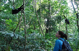
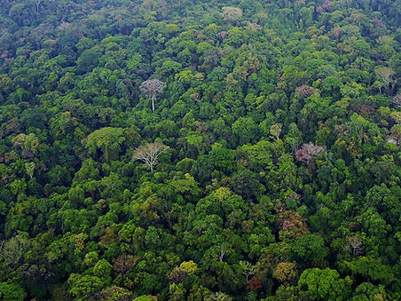

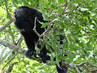
La imagen a la izquierda muestra un segmento de la selva del Parque Nacional Palenque habitada por lo cinco grupos de monos aulladores bajo estudio y uno de los drones usados en el proyecto.
The image to the left shows a segment of the forest of Palenque National Park inhabited by the five black howler monkey groups under study and one of the drones we use to monitor aspects of the forest canopy.
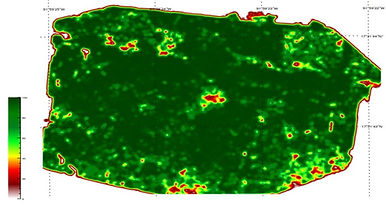
La imagen de abajo muestra un modelo generado con las fotos aereas tomadas por el drone del procentage por metro cuadrado de la cobertura de las copas en un segmento de la selva. El rojo del gradiente indica ausencia de conecividad entre copas y verde claro conectividad baja.
The image below shows the algorithm-generated proportion of canopy cover per square meter for a segment of the forest. Red indicates The image above shows a segment of the forest of Palenque National Park inhabited by the five groups under study and one of our drones. the absence of canopy connectivity and light green indicates low canopy connectivity.
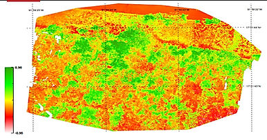
La imagen de abajo muestra el mismo ortomosaico pero en donde se ha modelado la reflectancia de la vegetacion (en este caso el indice NDVI (Normalized Difference Vegetative Index) . El verde indica la vegetacion mas fotosinteticamente activa.
The image below shows the same ortho-mosaic but where the algorithm has modeled the distribution of the vegetation with higher photosynthetic activity (green) expressed as the Normalized Difference Vegetative Index (NDVI).
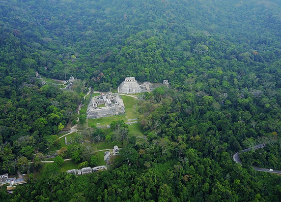
Abajo, imagen aerea tomada con el drone de un sector de la selva del Parque Nacional Palenque con las ruinas Mayas a la vista. Las selva arriba y a la derecha es el area es donde habitan los cinco grupos de monos aulladores negros bajo estudio.
Below, drone aerial image of a sector of the forest of Palenque National Park with the ancient Mayan ruins showing. The area of forest above and to the right is where our five study black howler monkey groups live.
